Morphologische Studie Untere Iller (Fkm 56,725 - Mündung) - Phase 2
- Inhalt
-
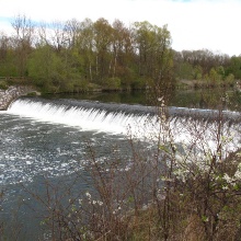
A coupled one- and two dimensional numerical sediment transport model is applied to investigate morphological changes of the Lower Iller on a length of nearly 57 km. In a first step the calibrated and validated model is used to identify areas where progressive erosion occurs and severe river bed degradation is expected in the future (simulation period of 50 years). For these specific sections measures such as open revetments, river bed widening and/or sediment feeding are implemented and tested within the model in a second step. Based on the results of the numerical simulations suggestions regarding the different measures (e.g. the number of open revetments including their lengths) will be given and a strategy for an optimized combination of them will be elaborated to stop the progressive river bed degradation.
- Leiter
-
- Bearbeiter
-
Lydia Seitz
Alexander Kikillus - Abteilung
- Zeitraum
-
Von: 01.01.2014
Bis: 31.01.2016
- Finanzen
-
Regierungspräsidium Tübingen
-